

Navigating in the sea ice towards 88° North with the Norwegian Coast Guard
In summer 2025, the HiAOOS-25 (High Arctic Ocean Observing System) scientific expedition was carried out onboard the Norwegian Coast Guard icebreaker KV Svalbard. The expedition was coordinated by the Nansen Environmental and Remote Sensing Center in close collaboration with the Norwegian Coast Guard, and supported several research initiatives, including the ArctSum-25 project led by the Norwegian Meteorological Institute. The primary mission was to deploy moorings and various types of ice-tethered buoys in the Nansen and Amundsen Basins. On 24 July, KV Svalbard departed from Svalbard and navigated deep into the Arctic sea ice, reaching nearly 88° North. For the ArctSum-25 campaign, the expedition offered a unique opportunity to deploy drifting buoys in a sparsely observed region of the Arctic Ocean, while also integrating scientific data collection with operational experience aboard the icebreaker. The cruise demonstrated the value of practical collaboration between researchers and Arctic operators during complex ice operations, highlighting how joint efforts can yield critical insights into sea-ice dynamics, enhance situational awareness, and improve navigation strategies in extreme polar environments.

Left: Artistic view from KV Svalbard’s bridge, while navigating through sea-ice leads by means of sea-ice radar and satellite SAR information.
Right: Snapshot from the sea-ice route planning, SAR satellite data, and ArctSum-25 OpenMetBuoy drift positions, while navigating in the sea-ice. Picture and image credits: Malte Müller
Maritime activity in the Arctic continues to grow, especially around Svalbard, where tourism has become a major driver. In recent years, this has included a notable increase in expedition and cruise traffic, particularly during the shoulder seasons. These periods, spring and late autumn, have become more accessible due to declining sea-ice extent. However, they are also marked by rapidly changing weather and sea-ice conditions. The concept of “last-chance tourism,” where visitors seek to experience polar environments before they disappear, adds further pressure on Arctic shipping activities. Thus, for the Norwegian Coast Guard, which is tasked with search and rescue, surveillance, and environmental protection in these waters, the ability to operate safely and efficiently in sea-ice-covered regions is essential.

Left: Shipping days of cruise and passenger vessels around Svalbard from 2012 to 2023.
Right: Blue dashed lines indicate the region where Norway has the responsibility for Search and Rescue in the Polar Code area.
Figures adapted from Müller et al. 2023.
During the HiAOOS-25 expedition in July and August 2025, a scientific transect was conducted through the Amundsen and Nansen Basins, navigating northward through challenging sea-ice conditions. As part of the ArctSum-25 campaign, 16 autonomous scientific buoys were deployed to collect in situ data on sea-ice drift, wave activity, and the vertical temperature structure from the atmosphere through the ocean column in these remote Arctic regions. The observational coverage was further strengthened by the WWRP-PCAPS endorsed project “Canada–Sweden Arctic Ocean Expedition 2025,” with three additional buoys that were deployed in the central Arctic Ocean in support of the ArctSum-25 campaign. Together, these efforts significantly enhanced the spatial and temporal resolution of data in a largely undersampled area, providing valuable insights into polar atmosphere, ocean, and sea-ice dynamics.
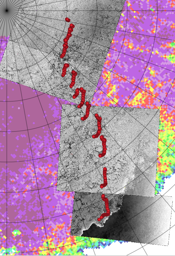
Deployment of 19 buoys across the Amundsen and Nansen Basins. Drift patterns (red points) of the 16 buoys (until August 9, 2025). Background SAR satellite data from RADARSAT (August 8 and 9, 2025), as well as AMSR passive microwave (August 8, 2025). Figure credits: Malte Müller
The OpenMetBuoy system that has been used consists of lightweight, cost-effective platforms designed to capture high-resolution observations over time. Their data provide valuable input for understanding sea-ice dynamics, wave-ice, and air-ice interactions. The buoys transmit the observations in near-real time. A live map and more information can be found here.
Navigation through sea ice in summer relies heavily on Synthetic Aperture Radar (SAR) data from satellites such as Sentinel-1 and RADARSAT. These images provide detailed snapshots of sea-ice conditions and are used to identify potential routes through leads (open water channels within the ice). Satellite data, particularly SAR data, is integrated into the KV Svalbard’s navigation system, enabling safe and informed decision-making during operations in ice-covered waters. The crew onboard KV Svalbard has developed substantial expertise in interpreting SAR imagery and other satellite-based data, gained through previous expeditions to the North Pole in summer 2019 and to the Beaufort Sea in late autumn 2020. However, the effectiveness of this capability depends critically on the timely delivery of geo-referenced satellite images.
Due to delays in satellite data availability, often ranging from several hours to a full day, navigators must frequently interpret this information manually and in real time. They align satellite imagery with observations from the ship’s radar and visual assessments from the bridge. Additional environmental data, such as wind, tides, and ocean currents, are also incorporated into the decision-making process to ensure safe passage through dynamic and potentially hazardous ice conditions.
During the ArctSum-25 campaign, the availability of real-time drift data from the deployed buoys added an additional layer of information. By integrating the position into the navigation system, this helped the crew refine their understanding of local drift patterns and made it easier to interpret the SAR imagery. Still, the campaign also highlighted some challenges: while platforms like PolarView offer user-friendly interfaces for SAR data, image quality can vary due to factors such as limited access to GeoTIFF formats for RADARSAT or inconsistent processing of satellite products.
The support from the crew in planning and deploying the ArctSum-25 buoy network was invaluable. In addition, the expedition offered a unique opportunity to gain insight into how navigational decisions are made under real-world conditions. Observing how data is used operationally and then adjusting products accordingly is a core principle of PCAPS: to develop observing systems and tools that are useful, usable, and used. The ArctSum-25 campaign is also closely linked to ongoing work within PCAPS task teams, such as DON4FS (Distributed Observation Networks to Advance Forecasting Systems), which aims to identify how distributed in situ systems can best support future forecasting capabilities. Furthermore, the campaign builds on earlier PCAPS-supported initiatives, including the SvalMIZ campaign, whose dataset was released in 2024, and the related workshop held earlier this year.

Scientific presentation for the crew of KV Svalbard by Alessio Canclini (MET Norway, University of Oslo) on his MSc thesis project on 100-meter-scale sea-ice prediction. Picture credits: Håkon Sandven
A great example of the synergy between research and operations is the master’s thesis project of Alessio Canclini (MET Norway / University of Oslo), who is developing a machine learning model to potentially support the navigator’s interpretation of SAR images. He participated in the ArctSum-25 campaign and presented and discussed his project idea with the KV Svalbard crew. He plans to forecast the “translation” of satellite images with a forecast horizon of 12 to 24 hours, by utilizing a machine learning approach and large amounts of satellite data, as well as buoy data from previous campaigns for verification. This has the potential to pave the way for more automated, AI-supported decision tools in ice-covered waters.
This type of hands-on fieldwork and cross-disciplinary cooperation exemplifies the aims of PCAPS. By linking observations, modeling, and operational practice, these initiatives are helping to build a more integrated Arctic observing system, one that supports safety, research, and sustainability as the region continues to change.